Geospatial

Designed For Geospatial

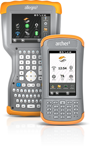
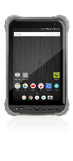
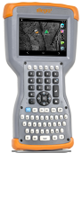
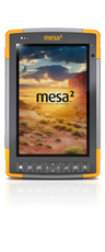
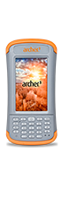
Juniper Systems rugged handheld computers are used in a variety of geospatial applications, including land survey, construction survey, and forensics mapping. Combined with the extraordinary solutions provided by our valuable geospatial business partners, Juniper Systems rugged data collectors offer integrated GPS and sub-meter DGPS, digital camera, Bluetooth®, Wi-Fi, and cell modem connectivity, as well as devices with full alphanumeric keyboards.

Our geospatial customers rely on our rugged handhelds to be the ideal tools for mapping, surveying, and GIS data collection applications due to the ultra-rugged construction, ergonomic design, long-term battery life, sunlight readable displays, and expandable/customizable solutions. Contact Juniper Systems today to find your perfect geospatial solution!

Land Survey Products

Whether you’re mapping property boundaries, designing and laying out lots and subdivisions, or taking precision measurements of angles and elevation, Juniper Systems rugged data collectors are your ideal companions for collecting land survey data. Increase your efficiency and productivity while improving the land around you by relying on Juniper Systems for all your land surveying needs.

Rugged Handhelds

Land Survey Applications

All Juniper Systems rugged handhelds and tablets feature an ultra-rugged design (waterproof, dustproof, shockproof), sunlight readable displays, long battery life, ergonomic design, and field-swapable batteries. Options for GPS, cameras with geotagging capabilities, barcode scanner, and RFID are also available.

  • Property Boundaries
  • GPS And Mapping
  • Lot Design and Layout
  • Elevation and Angle Measurements
  • Forensic Mapping
  • Crime Scene Mapping

Construction Products

While dealing with some of the most demanding environments on earth, construction surveyors and managers look to Juniper Rugged™ handhelds to accurately stake out reference points and markers to guide construction projects and manage all aspects of their project on-site. Juniper Rugged handhelds will undoubtedly withstand both scorching and frigid temperatures, high drops, rain and snow, heavy machinery, and extreme amounts of dirt and dust, all of which are everyday elements in construction survey.

Construction Applications

All Juniper Systems rugged handhelds and tablets feature an ultra-rugged design (waterproof, dustproof, shockproof), sunlight readable displays, long battery life, ergonomic design, and field-swapable batteries. Options for GPS, cameras with geotagging capabilities, barcode scanner, and RFID are also available.

  • Construction Survey
  • GPS & Mapping
  • Project Management
  • Inspection
  • Timecard & Crew Management
  • Work Orders
  • Billing & Record Keeping
  • Design Review

Geospatial Partners & Solutions

Carlson Software
Carlson

Carlson Software specializes in CAD software, field data collection, and machine control products for the land surveying, civil engineering, construction, and mining industries worldwide, providing one-source technology solutions from data collection to design to construction. Carlson’s offering of rugged data collectors include the Carlson MINI2 (Archer 2) and the Carlson Surveyor2 (Allegro 2).

Topcon Positioning Systems

Topcon is a world-leading manufacturer of laser and optical surveying instruments. Topcon offers positioning systems that significantly improve the productivity and quality of work performed in civil engineering, agricultural, mapping, and measurement application markets. Solutions consist of total stations, digital levels, lasers, GPS receivers, and data collectors, including the Tesla and FC-500 Field Controllers.

MicroSurvey

MicroSurvey develops, manufactures and markets a family of specialized computer software for land surveyors, civil engineers, seismic surveyors, mapping professionals, police officers, and accident reconstruction specialists. The Mesa and Archer 2 are available for purchase through MicroSurvey and come with FieldGenius Standard data collection software.

Altus Positioning Systems

Altus Positioning Systems is dedicated to providing customers with first class positioning system products and freedom of choice. Altus carefully designs high-quality products to meet the needs of today's surveyor, based on many years of involvement in instrument design and construction. Altus offers several rugged data collectors to complete its solutions, including the Mesa, Archer 2, and Allegro 2.

Sokkia

Sokkia is a world-leading manufacturer of precision measuring systems. Sokkia's diverse product line provides complete measurement solutions for surveying, mapping and GIS, industrial measurement and construction applications. Solutions consist of total stations, digital levels, lasers, and data collectors, including the Mesa Rugged Notepad and Archer 2.

Position Partners

Position Partners is Australia’s premier provider of positioning and machine control solutions for land management, civil works and building activities. The Archer 2, Allegro 2, and Mesa Rugged Notepad are available for purchase through Position Partners.

Sigma Enterprises LLC

Sigma Enterprises LLC is an Engineering Technology company offering products and services across the GCC. Sigma supports the engineering equipment requirement of diverse industries including civil engineering, manufacturing, oil and gas, defense and security, education and research, and marine.

Septentrio Satellite Navigation

Septentrio Satellite Navigation NV, designs, manufactures, markets, and supports high-end dual-frequency GNSS receivers with the best possible performance at a competitive price. Targeted at original equipment manufacturers (OEMs), Septentrio’s core technology is applied in precise positioning, timing, and attitude determination applications.